
Do you want to read something really interesting? We live in amazing times. I was looking for a piece of information the other day as I was preparing to write an article on the Elkhorn Ranch. Google. Up popped this Bismarck Tribune article from 2004. I had forgotten some of the modern history behind the goings-on at the Elkhorn Ranch and the Eberts Ranch. Now, thanks to modern technology and some foresight on the part of the Tribune, I’m going to let Tribune reporter Lauren Donavon, who is still writing about this stuff for the Tribune, write today’s article for me. It’s an awfully good story. Darn, I wish her editors would still let her write this way. Maybe they will again, one of these days. Anyway, here’s her story, printed in full from the October 17, 2004 issue of the Bismarck Tribune. I’ve added some updates of my own where appropriate.
EBERTS RANCH – North Dakotans may one day point to the Badlands and say, “We own a piece of that.”
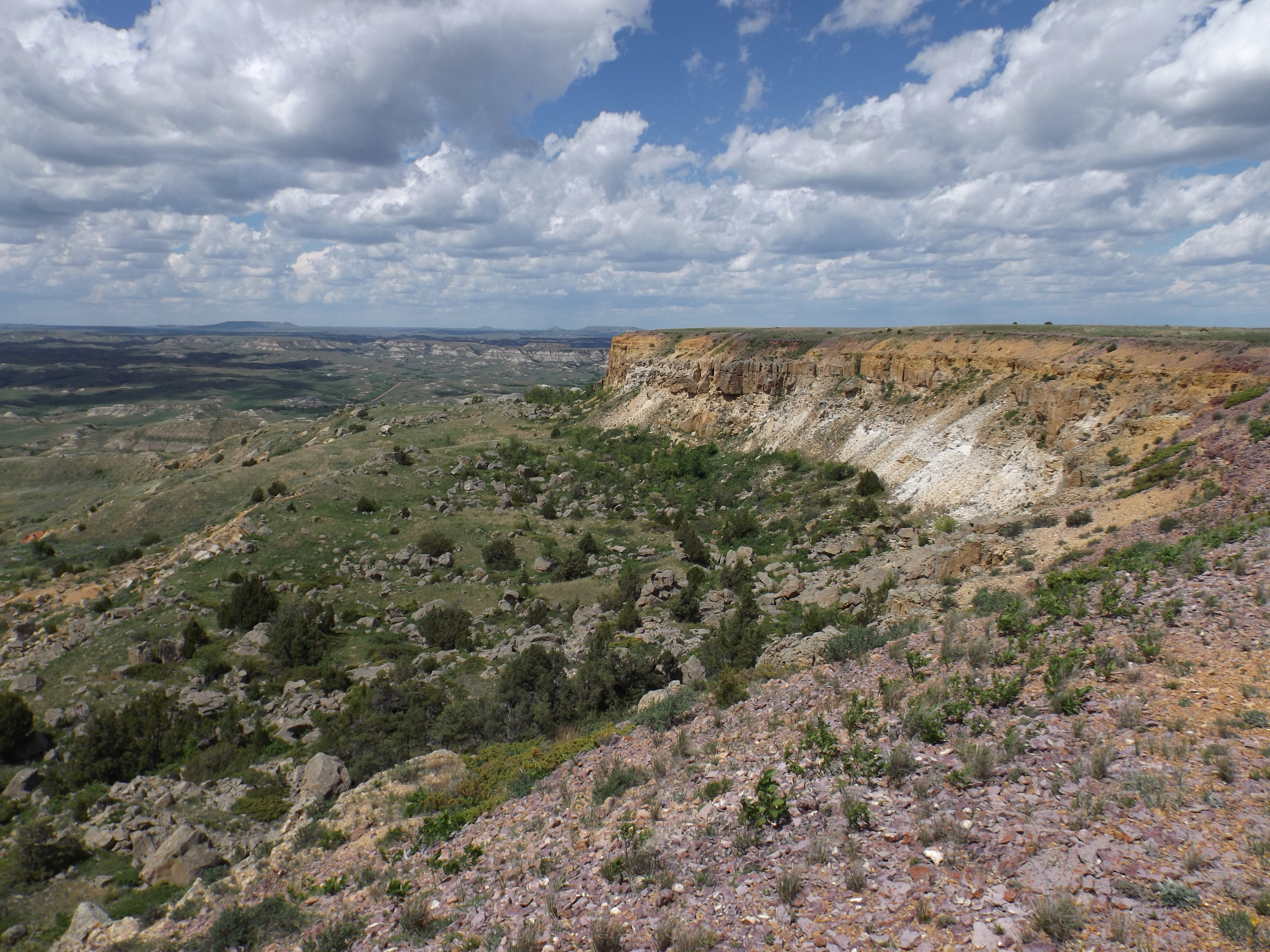
That piece is the Eberts Ranch. It’s a place of great natural beauty in the rugged heart of Little Missouri River country north of Medora.
The family – three brothers and their wives – wants to sell their 5,200 acres for preservation. It looks like North Dakota may buy it with plans to use the land in diverse ways for the pleasure of the public.
The idea seems simple enough and guarantees mainly winners all around: the Ebertses realize their dream of preserving land that was once part of Theodore Roosevelt’s cattle ranch; the public gets rare access to river-laced Badlands; and, while not a person, the land becomes a state treasure, preserved from development for all time.
The only other state-owned land developed for recreation on the river is the small Sully Creek Campground near Medora (Update: Which now has a scruffy RV Park/Man Camp across the road from it) and the Little Missouri State Park north of Killdeer (Update: Which is now in the middle of an oil field), which overlooks the river rather than hugs it.
If the Ebertses’ idea seems simple, it hasn’t been. It’s been as tricky as riding a horse down a muddy clay butte, slippery footing all the way.
The Eberts brothers, Ken, Allan and Dennis, might be called naive for not forecasting the mud – if not the slippery footing – when they first proposed selling their ranch to the National Park Service in 2002.
Their idea, which was liked by the park service, was to make the ranch an extension of the Theodore Roosevelt National Park’s Elkhorn Ranch Site. The Elkhorn site is a stone’s throw across the Little Mo from the Ebertses’.
Roosevelt’s cattle free-ranged up and down the river back in the 1880s. From his cabin porch, the future president enjoyed and wrote about his view of a razor-backed ridge on the Ebertses, for the way it pinked up in the glow of a fading sunset (Update: Soon, the view from that spot may be of a gravel mining pit.).
Not that rosy now
The Ebertses have been to the brink of a sale and back again, more than once. (Update: The ranch was finally sold to the U.S. Forest Service in 2007.) They have faced down criticism from other ranchers, who say it’s not a good idea to take a private ranch out of the economy. They say the ranching tradition is the big loser in the equation. Others said making the ranch into public land would impair oil development, hunting and grazing and county tax revenue.
Most recently, the Billings County Commission issued notice that it plans to take a road on the Eberts ranch for a river crossing, an action the Ebertses say is intended to interfere with the locally unpopular sale and follows the county’s own criticism of the idea.
At the moment, the road taking and the river crossing are the Ebertses’ problem. Pat Weir, the county’s attorney on the matter, said the county is waiting for Southwest District Judge Ron Hilden’s order.
The judge recently extended an injunction that stops the county from surveying the ranch for the best crossing site and the order should clarify what happens next.
“That starts the clock on what we may or may not do,” Weir said. (Update: Judge Hilden passed away a couple years ago. Weir replaced him as judge.)
Ken Eberts – the brother who lives on the ranch – said the situation is not pleasant.
“These things are ugly,” he said. “It’s put a strain on everything.”
His wife, Norma Eberts, said had the family known what was in store, it wouldn’t have had the collective heart to try to sell the ranch for preservation.
The purchase of the ranch by North Dakota and the taking of the road by Billings County might both proceed.
In that case, North Dakota would own a piece of beautiful land, roughly dissected by an improved road leading to the only river crossing between I-94 and the park’s North Unit, a distance of roughly 70 miles.
Lance Gaebe is farm policy adviser to Gov. John Hoeven. He’s been working on the Eberts deal for more than a year, ever since North Dakota stepped in with a half-and-half ownership plan with the National Park Service. (Update: Gov. Hoeven is now a United States Senator. Gaebe is now Governor Dalrymple’s State Land Commissioner, and is leasing the land the state owns for oil development as fast as you can say “Bakken Shale.” Maybe it’s a good thing the state didn’t get to buy this.)
For now, federal legislation to fund purchase of half the ranch for a national park, or even a more user-friendly preserve with permissible hunting and oil development, is on hold.
Sen. Byron Dorgan, D-N.D., said it’s not a dead issue and he’ll continue to try to steer a federal appropriation for the purchase through Congress, perhaps in a big omnibus appropriations bill this winter.
“There’s never any certainty,” Dorgan said. (Update: Local opposition to having the Park Service own the ranch was too strong for Dorgan to overcome. He finally finessed a deal to get a federal appropriation for the U.S. Forest Service to buy the land, with help from private fundraising led by a national coalition with interests in the history of Theodore Roosevelt in the Bad lands.)
Meanwhile, North Dakota is going ahead on its own.
Gaebe said he is hopeful he can put together the $3 million – roughly $600 an acre purchase price – by the end of the year.
About $2 million would come from the federal Natural Resource Conservation Service grasslands reserve program and another $500,000 from the federal Land and Water Conservation fund. The state would ante up the remaining $500,000. (Update: the purchase was shot down by the North Dakota Legislature in 2005.)
The Ebertses are waiting. They say that’s less than they could get in a private sale, though that claim is met with skepticism at the Billings County Courthouse.
Gaebe said it would be simpler if the ownership were not split between state and federal agencies.
He said the State Parks Department would manage the property as a working ranch preserve, where people could experience ranch life, and hunt and camp under primitive conditions at a location crossed by the popular Maah Daah Hey Trail. Oil development would also continue.
It’s an idea never tried before in North Dakota.
Gaebe said the Hoeven administration is “tickled” at the opportunity to add the ranch to its inventory of public-use lands and save it from ever being broken up into obtrusive ranchettes.
“Hopefully, we can make it happen,” Gaebe said. “It should be protected.” (Update: Go back two paragraphs where it reads “Oil development would continue. Is that someone’s idea of protection?)
A road running through it
That a public road might run through the heart of the ranch is relatively new news to North Dakota, though Billings County said no one should have been surprised at the quick take notice served to the Ebertses in August.
The Ebertses successfully asked the court for an injunction against the action and for now it’s not clear what will happen.
The county says it is perfectly within its rights to take an easement for public use in a process that first takes and settles financial damages later.
Gaebe said if the state buys the ranch, it would try to work with the county. Ideally, he’d prefer some traffic restrictions, like oil field and commercial traffic limited to weekdays and permitted access to ranch neighbors.
The Ebertses say turning four miles of their private road into a public road to cross the Little Missouri will be a huge intrusion on the ranch, besides hampering the sale.
The road in question cuts through the calving pasture and runs within 50 yards of ranch buildings on its way to the Little Missouri River.
The river crossing where a gravel bottom makes it possible to drive over in low water has been closed for years, except to some utilities, the Ebertses say.
Bridge is an old idea
Billings County has been working on a river crossing in the Ebertses’ vicinity since the mid-’70s.
Laura Griffin is Billings County tax director and land assessor. She has a stack of studies, meeting minutes and environmental assessments that stand a foot and a half high to attest to the county’s long quest.
Back in the ’80s, Golden Valley and Billings counties agreed that each county would build roads coming toward the river. Golden Valley would build from the west and Billings County from the east, eventually connecting state Highways 16 and 85 on either side of the Badlands.
The last piece of the east-west passage was for Billings County to build a span bridge over the Little Missouri River and finally provide a public crossing for commerce and agriculture.
Billings County has spent more than $4 million to build Blacktail Road, which comes up to the Eberts property from paved Highway 85. Golden Valley’s share of the east-west road is complete to the Billings County line on the west side of the river.
Initially, the final piece of road and bridge were to be built south of the Ebertses’ on the Mosser ranch, crossing over onto a small piece of Elkhorn Ranch site buffer land owned by the State Historical Society (Update: This would have put the bridge just a couple hundred yards from the actual NPS Elkhorn Ranch Site—a very bad idea.).
Griffin said the bridge eventually drew so much environmental criticism that in 1993, the county withdrew a construction permit application with the U.S. Army Corps of Engineers. That same year, according to county records, the county approached the Ebertses, who had just acquired ownership of the ranch from Les and Jack Connell.
A crossing at the Ebertses’ kept the county lined up with the road on the other side, plus it would be a solid mile north of the Elkhorn Ranch site.
The Ebertses said they would sell an easement for $300,000, according to a letter from their attorney, Al Hardy, of Dickinson.
The county said “thanks, but no thanks” and turned down the offer.
In a same but different echo of the Ebertses’, Griffin says if the county knew then what it knows now, it would have written that check and been done with it.
Jim Arthaud is a former Billings County commissioner and the county’s representative on the Ebertses’ dealings (Update: Arthaud is now chairman of the Billings County Commission. And a much wealthier man than he was eight years ago. He owns one of the biggest fracking water-hauling businesses in the Oil Patch and would be a major user of this road—perhaps the biggest user of this road). He said the Ebertses should not act as though the road taking comes from out of the blue, just in time to interfere with the sale.
“They were plumb fine with $300,000,” Arthaud said. “They weren’t born yesterday.”
The Ebertses say they were green from just having landed on the ranch and didn’t know the historical significance of the property.
The Ebertses said they eventually realized how a road, carrying heavy oil truck traffic, would have cut right next to the ranch buildings.
That exchange in 1993 is the last formal communication with the Ebertses, though the county conducted another study and applied for another bridge construction permit there in 1995.
That permit was withdrawn in 1997 and now, instead of a substantial bridge span, the county is planning to build a concrete low-water crossing from the Ebertses to the other side.
Bridge evolving
A low-water crossing is less environmentally intrusive. At an estimated $500,000, it’s also about one-fourth what a span bridge would cost. (Update: Ask canoers and kayakers which they prefer. You can float under a bridge. You have to get out and unload and drag your canoe over a low water crossing.)
The Ebertses might be excused for thinking the notice they got in August advising them the county planned to quickly take their land felt like an ambush.
It had been years between formal contacts from Billings County. Griffin and Arthaud said the county was never silent on the matter and routinely kicked around options at meetings.
By 1997, the county knew that a new proposed management plan by the U.S. Forest Service would change uses of forest service land along the river up and around the Ebertses’. Arthaud said when the management plan was made final two years ago, it created a series of scenic areas along the river, as well as designated bighorn sheep habitat.
Between the fact that the county can’t maneuver too far north and south and still logically meet roads on either side of the river, plus restrictions on Forest Service land, the county doesn’t have any other option, he said (Update: The best option, which would eliminate most of the controversy, would be to move the road north into McKenzie County, which is actually one of the alternatives to be discussed at public meetings on the issue this week in Bismarck and Medora. But that would bruise some big Billings county egos.).
“With everything we’ve looked at, this is the only place we can put it in,” Arthaud said. (Update: There are actually a number of viable alternatives for the river crossing. You can look at a map that shows them by going to the Billings county website here and clicking on the map on the right side of the page.) “The sale is irrelevant. It’s not been sold to anybody and it may not be sold.”
Maure Sands, acting land manager for the Forest Service, said his agency is not directly involved because the proposed crossing involves private, not Forest Service land, on either side.
“We are interested in the outcome,” he said. Besides the Ebertses, though, the county may have Theodore Roosevelt National Park to contend with.
The Elkhorn Ranch Site is the most important historical feature protected by the park, something like a Walden Pond of the west, said chief interpretive ranger Bruce Kaye.
The impact from noise and dust from a crossing even a mile from the Elkhorn Ranch would be an issue, Kaye said.
He said the park would be “very much involved” in a river crossing near the site, though it’s not yet clear what form its involvement would take.
“We’ll do whatever it takes to protect that,” he said.
Oil activity abounds
Billing County’s oil map looks like a multi-colored mosaic. Each color block is a different permitted oil field and there are 30 of them north of Medora, some on the west side of the Little Missouri and some on the east side. (Update: That was then. This is now. Who knows how many there are now. Things are moving so fast there’s no way to keep track.)
There are oil wells throughout the county, including seven on the Eberts ranch. Oil field traffic – if it has well service stops on both sides of the river – has to detour down to I-94, a trip that can take from six hours to 10, depending on road conditions.
Arthaud, who also owns a well service business out of Belfield, said that detour happens all the time, many times a day. He estimates between 25 and 50 oil service trucks would pass through the Ebertses’ and across the Little Missouri daily if the road becomes public. (Update: That was 8 years ago, BEFORE the oil boom hit. You could probably add a zero to each of those figures if the road and bridge were built today. NOW you see why everyone is so concerned about the proximity to the Elklhorn.) Despite Gaebe’s idea of a compromise, he said the county would not be open to restricting commercial use to weekdays.
“The oil field doesn’t stop at 5 p.m. on Fridays and hay hauling and utilities don’t stop at 5 p.m. on Fridays,” Arthaud said. “This is our county. It’s not a wilderness.”
The Ebertses prefer a crossing further north. They say any crossing would be little used by any but oil traffic, since the relatively few people who live out in the Badlands take their trade and school-aged children to communities on their side of the river. (Update: Kenand Norma Eberts were exactly right about that. There is absolutely no demand for this road by anyone but the oil industry.)
The last word
Too bad Theodore Roosevelt can’t weigh in on the subject. Both an avid preservationist and colorful entrepreneur, he might provide some useful insights. (Update: In a sense, he is. His great grandson, Tweed Roosevelt, president of the Congressionally-chartered Theodore Roosevelt Association, the organization charged with preserving TR’s legacy, has mounted a national campaign to stop this madness.)
His presidency marked a vast expansion of the country’s public lands, but he always maintained that it was his cattle ranching days in the Badlands that gave him the character to become president.
He on horseback, and his cattle, crossed and recrossed the river constantly to a meadow on the Ebertses’ river bottomland and beyond. (Update: If you go there now, and hike down to the Little Missouri River, at most times of the year you can wade across the river onto the Eberts Ranch, now known as the Elkhorn Ranchlands. Or if you’re a horse rider, you can ride your own horse across. It’s okay, We own all the land. For now.)
There is little doubt he would instantly grasp the conflict between those who would preserve the land and those who would use it, both for private ranching and commercial traffic.
Perhaps the last word belongs to the Eberts. Some might question their motives, but the family says selling the land for preservation is not a scheme to make them “filthy rich” and nor did they ever anticipate being in a lawsuit with the county over a road matter.
They say they want the land – historically rich and undeniably beautiful – to be recognized and secured for what it is.
“We think it needs to be protected at all costs,” said Norma Eberts. “North Dakota has a good plan.”
Final Update: Norma Eberts was right. The state did have a pretty good plan. But the Legislature shot it down. The land was eventually sold to the U.S. Forest Service and grazing continues there while the Forest Service works out a management plan for the ranch. The two immediate threats to the ranch are the nearby river crossing, referred to here, and the gravel mining operation, which has been the subject of a number of articles here. Greed seems to grow exponentially in western North Dakota these days. What will happen next is anyone’s guess. But this place is worth fighting for.

My partner and I stumbled over here coming from a different page and thought I may as
well check things out. I like what I see so now i’m following you.
Look forward to checking out your web page repeatedly.
LikeLike