
The impact of the oil boom has left North Dakota—and many North Dakotans—in the most amazing financial position we have ever experienced, or could ever have imagined. That’s good. I was State Tourism Director back in the 1980’s when a pair of Rutgers University professors suggested we turn western North Dakota into something called the Buffalo Commons—open range with herds of buffalo roaming like they did as recently as 150 years ago. After all, the federal government already owned a million acres of grazing land in western North Dakota, and it was pretty spectacular country: The Bad Lands of the Little Missouri River. All the government would have to do is buy up about another million acres or so from the ranchers who owned the private land within the rough boundaries of the Little Missouri National Grasslands and they’d own a huge block of open range. They could turn the buffalo loose, and then set up a visitor infrastructure of guest ranches and motels and RV parks and restaurants and gift shops and outfitters and they’d have one of the best tourist destinations in America.
Of course there was the predictable mighty outcry from North Dakotans—ranchers and farm organizations and chambers of commerce and politicians—but I have to admit that as a tourism director who happened to like the idea of wilderness, the idea had some appeal. But I worked for a politician, so I kept my mouth shut.
In those days we were reeling backward from a bust of an earlier oil boom. There were hard times on the prairie. We didn’t know then, that there would be another boom. We were just trying desperately to save what was left of our population base. We were holding symposiums on how to stem out-migration. We were creating government incentive programs to try to stimulate new businesses who would hire young people to keep them in the state. We were aghast that someone might suggest that depopulation might just be a good thing. We ran Frank and Debora Popper out on a rail and told them never to come back.
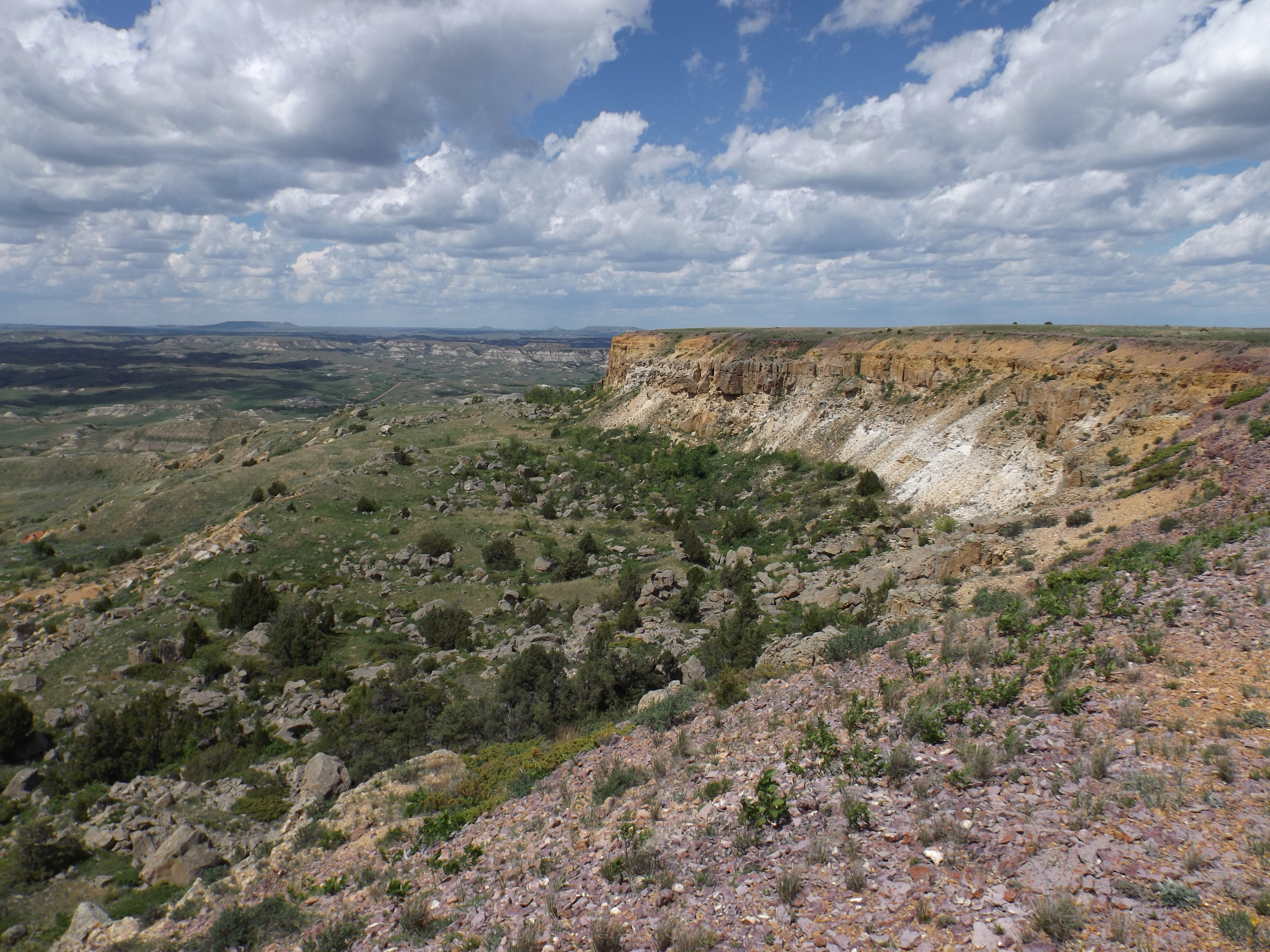
It wasn’t that long ago we had half a million acres of the national grasslands, our publicly owned land, still pretty much in a pristine state. In the early 1970’s I used to spend time in a place we called the Bell Lake Wilderness. It wasn’t really a true, federally-designated wilderness area, but it was a block of public land northwest of Medora, without many roads on it, no ranch dwellings, and lots of great hiking. It was one big block of about 30,000 acres, and only four little pieces totaling about a thousand acres of it was privately owned.
We used to drive there late in the day, park on the road or drive in a little ways, hike in with our camping gear, and spend the weekend hiking and camping. We never saw or heard another human. Today, that area is known as the Bell Lake Oil Field, and every single acre of it is leased for oil development. Every acre. The truck traffic by the area these days is something to behold.
Today there are very few places in the Bad Lands where you are free from truck noise and dust clouds. In this long article (hey, you don’t have to read it all at once—like the oil in the Bakken formation, it’s not going anywhere) I’m going to talk about the threats to the few really good places left in the Bad Lands today as a result of this oil boom.
I’ve written about most of these places before, so this is kind of a recapitulation, an update, on the status of the threats posed to some very important places in North Dakota. I’ll include some links to previous articles at the end of this post. Every day now, you’re exposed to stories in the media about negative impacts of the oil boom: dramatically increased crime rates, severe housing shortages to the extent people are living in cars, exorbitant rent and home prices, teacher shortages, road damage, traffic jams and traffic fatalities, manpower shortages, lack of people available to fill service jobs—the list goes on and on.
But the elephant in the room is what is happening to the land. No one is talking about that. And the critters who live there can’t talk to us about it, although we’re seeing some pretty dramatic statements from them in their reproductive activities. Everyone likes a little privacy when they’re committing procreative acts, including mule deer and antelope. North Dakota government officials won’t talk about it—it is one of the really, I believe, valid criticisms of state government failing to act in the face of this oil boom on an issue of importance—but the fact that there is no antelope season again this year, and no mule deer doe season in the Bad Lands, is pretty telling. Antelope and mule deer, of course, live in the counties that make up the oil patch. Antelope and mule deer populations are drastically low. Coincidence? I don’t think so.
As for white tail deer, our Game and Fish Department issued 65,000 licenses to hunters this fall. That’s 45,000 fewer than last year, a drop of about 40 per cent, and the lowest number of licenses since 1988. Coincidence? I don’t think so.
Game and Fish officials, at the insistence of the governor, who doesn’t want any bad news regarding this marvelous windfall for North Dakota in an election year, are blaming it on bad winter weather. Fact is, deer mate in the fall, not in the winter, and they don’t mate at all with a thousand oilfield trucks a day roaring through their bedrooms. We did have some bad winter weather for a few years, a while back. We’re pretty much known for bad winter weather, and the critters have always survived here. But last year we had one of the mildest winters on record. So, many of us aren’t buying the story that the low animal populations are a result of only bad weather. To be sure, we’ll be tracking deer and antelope populations for the next few years, and measuring that against the winter weather. But by the time we are proven right, it might just be too late for the critters. And the hunters.
The point is that amidst all the benefits of the oil boom, and the recognition of the social problems being caused in our cities and on our highways, what’s not being talked about is the oil boom’s impact on the land and the critters who live there. I’m going to give you five specific examples of things that have happened in the last year, and are ongoing.
1. Bullion Butte
Since statehood, the state of North Dakota, like most other western states, has owned two sections of land in every township in the state. And the minerals under that land. County atlases will show you that the state owns section 16 and 36 in every township in North Dakota. Well, not quite. Some have been sold over the years, but the state reserves the mineral rights under them to this day, so the state owns or manages minerals under 2½ million acres of land—the largest landowner and mineral owner in the state. Some of those sections—a very few–happen to be inside areas in the Bad Lands being managed by the U.S. Forest Service as roadless areas, suitable for wilderness designation. Others are in very sensitive Bad Lands areas, such as bighorn sheep lambing grounds. The fellow charged with managing those mineral acres—all 2 ½ million of them—holds a quarterly mineral lease sale at which he auctions off the rights to drill for oil under those lands. The way it works is, agents for the oil companies search courthouse records looking for land under which the minerals are not now leased, or on which leases are about to expire, and they nominate them for lease at the next auction. Then they bid for the right to drill for oil under them. All the money raised by the State Land Board goes into the Common Schools Trust Fund to support education in North Dakota. Lately that fund has been building up nicely, into the hundreds of millions of dollars.
Last winter, an oil company nominated a number of parcels that were in environmentally sensitive areas, such as Bighorn Sheep lambing grounds, and including a section of land inside the roadless area that makes up the Bullion Butte “suitable for wilderness” area, and the Land Commissioner put them on the auction list. Well, luckily for us, the local representative of the Wildlife Society was checking the list of nominated lands and saw that these sections were going to be leased. If that happened—if the section inside the “suitable for wilderness” area was leased—a mess was going to ensue, because an oil company would want to drive in there, through the roadless area, to set up its drilling rig. That would threaten the whole roadless concept, or set off a huge legal battle between an oil company, the state, and the Forest Service. And who knows what the outcome of that would be?
Well, wildlife interests and the conservation community went right to the Governor, and the news media, and stories were published in newspapers and aired on TV and radio. Conservation groups asked for those tracts of land to be withdrawn from the auction. To which the Land Commissioner responded “Conservation doesn’t support education for my kids and grandkids.” He only said that once. I expect his bosses at the State Land Board said that was enough of that. And then the Governor, with great fanfare, announced that those tracts were being withdrawn from the auction. While everyone patted the Governor on the back for being sensitive to the environment, I called the Land Commissioner’s office and got the real story. What really happened is that the company that had originally nominated those tracts, after reading about the controversy it had created, had actually requested that the tracts be withdrawn from the auction, saying that it was no longer interested leasing them. They didn’t want any part of the publicity that was surrounding that issue.
Crisis averted. And the other result was that the Land Commissioner, at the instruction of his bosses, is now being very careful about the lands offered, and if they are in environmentally sensitive or wildlife-sensitive areas, he is placing restrictions on the leases saying that they might not allow any “surface occupancy” on those lands, requiring oil companies to drill in horizontally, or might be restricting which parts of those sections can have surface occupancy, so that the wells are placed away from woody draws, for example, where the deer and bighorn sheep live. The oil under those lands is still going to flow, but with some safeguards for the land.
2. Elkhorn Ranchlands Gravel Pit
A few years ago, the family that owned the ranch across the Little Missouri River from the Elkhorn Ranch site decided to retire. There were no children in the family who wanted to continue to ranch, so the ranch was going to be sold. Sensitive to the fact that the land was once part of Theodore Roosevelt’s ranch, and made up the greater part of the viewshed from the current National Park Service’s Elkhorn site, they offered to sell the land to the government. A national fundraising campaign began, headed up by the Boone and Crocket Club, and enough money was raised to buy the ranch and give it to the U.S. Forest Service, which managed most of the rest of the land on that side of the river.
Unfortunately they did not raise enough money to buy the minerals under the land. Mineral ownership had been severed from the land many years before. One of the mineral owners, who owned a quarter of what we call the “surface minerals”—gravel and scoria—sold his 25 per cent interest to a former area resident who now lives in eastern Montana. He’s not a nice man. He immediately announced that unless the government paid him two and a half million dollars for the minerals—a price he had picked out of the air but declared was reasonable—he was going to put a gravel pit on top the ridge directly across from the Elkhorn cabin site. Everyone knew, of course, that a gravel mining operation was going to be a huge distraction to everyone who enjoyed the Elkhorn site for its quiet, serene atmosphere. People also knew that because of the oil boom, there is a huge demand for gravel in western North Dakota, and that this fellow probably wouldn’t have a problem selling his gravel at a premium—although probably not for the price he was demanding in his blackmail offer. Well, maybe.
A couple weeks ago, I called up a local county auditor—over the years, county road departments have been the biggest gravel users in the state—to find to find out what gravel is selling for these days. She told me that three years ago, the county paid 65 cents a cubic yard for gravel. Her most recent contract was for $5.50 a cubic yard, about a 900 per cent increase. The problem, she said, is that these landowners who have gravel on their land can sell it to the oil companies, who are willing to pay, she’s heard, up to 10 or 12 dollars a cubic yard for it to put it on their well pads and access roads. She said trying to buy gravel these days is almost like a “covert operation”—her words. Some of the landowners want to help their counties, she said, and so will sell it to her, but it’s hard for them to turn down the money they can get from the oil companies, especially because these are people who don’t have the oil, and aren’t getting rich from oil royalties. This is their chance to cash in from the boom.
Well, anyway, this issue—the threat of a gravel mining operation on top the ridge across from the Elkhorn site—stirred for most of a year, with the conservation community again rearing up and defending the Elkhorn site. This fellow—we’ll call him Roger—said that the Sierra Club should just raise the money and buy him out. The Sierra Club politely declined. Finally, a couple of months ago, the Forest Service got Roger into a room and got him to sign an agreement that he would hold off on his mining plans for a while to allow them to try to find a suitable land or mineral swap arrangement—he’d get some land or some minerals somewhere else in a less sensitive area in return for giving his mineral ownership at the Elkhorn site to the Forest Service. Those negotiations are ongoing. I don’t think Roger is going to be easy to please—he feels like this is a “strike it rich” deal for him—so I don’t think this crisis is averted yet. But at least the mining shovels won’t be roaring next spring, as he had planned.
3. Little Missouri River Crossing
The Bakken Oil Field activity is still expanding, slowly stretching its southern boundary into the Bad Lands of northern Billings County, whose county seat is Medora, the state’s number one tourist attraction. The Bad Lands, of course, lie astride both sides of the Little Missouri River. As do the cattle ranches in the Bad Lands. As does the oil. For much of the year, the Little Missouri River is just a trickle, and ranchers have taken advantage of natural fords—enhanced often by some gravel they dump into the river bottom—to get back and forth across the river, mostly to check on their cattle. There are no bridges across the river between Medora and a spot 50 or so miles north where U.S. Highway 85 crosses the river. There’s never been a demand for a bridge. There are very few ranches along the river between the existing bridges, and they haven’t clamored for an improved river crossing in the 125 years there have been ranches in the Bad Lands. But the oil boom changed things.
There’s a fellow, we’ll call him Jim, who lives just south of Medora, on a mini-ranchette, who owns one of the largest trucking companies in North Dakota. His 600 trucks provide fracking water for the oil field, among other things. He’s also gotten himself elected chairman of the Billings County Commission. Recognizing that there’s going to be oil activity in his county, on both sides of the river, he’s proposed that the county build a new bridge across the river.
His original proposal was to put the bridge right up alongside the Elkhorn Ranch site. Just a few hundred yards south of where Roosevelt’s cabin sat. He said the bridge is needed because the oil industry is going to need to get a thousand trucks a day back and forth across the Little Missouri River to service their drilling operations. As outrageous as that may sound, a thousand trucks a day, on gravel roads, right up against the spot Americans call “The Cradle of Conservation” because it is where Roosevelt formulated his conservation ideas, he’s dead serious. Jim doesn’t have much patience with conservationists. He recently told a reporter “The whole public would be able to use that place, not just the elitist environmentalists. That lousy 50, however many acres it is, 200 acres or whatever, where Teddy sat there and rested his head and found himself.”
Billings County, one of the richest counties in North Dakota because of its oil revenues, could have just gone ahead and applied for a permit from the Corps of Engineers, which grants them routinely as a matter of course, and built the bridge. Instead, they decided to get federal funds to do it, which set off an environmental impact statement process, which is underway now. The Federal Highway Administration has held public hearings, and they have identified several possible alternative crossing sites, the most likely of which to be approved is three miles north of the Elkhorn, if indeed one is approved at all.
The thought of sending 1,000 trucks a day, on gravel roads, through the Little Missouri River Valley, one of America’s most pristine spots, boggles the mind. The potential dust clouds are unimaginable. The dust has to settle somewhere, and it will settle on the grasses that feed the cattle, and the alfalfa that is cut for hay, and the corn that feeds the cows in winter, making it all virtually unusable.
The alternative, of course, is to keep doing what we are doing now: keeping the trucks on the paved highways 15 miles east and west of the river, crossing the river on Interstate 94 at Medora or Highway 85 south of Watford City. Certainly more costly for the truckers like Jim. A shortcut saves him millions of dollars in fuel costs, eventually. Good deal for Jim. Especially since the American taxpayers will foot the bill for the bridge. And Billings County taxpayers will pay for the new gravel and the maintenance it’s going to require to keep up those gravel roads, which are going to take quite a beating from a thousand trucks a day. Most of them don’t get used by a thousand trucks a year.
The project is in the decision stage at the Federal Highway Administration now. They’ll tell us what they think sometime this coming winter. Then, if they approve a project, they have to ask Congress for the money to build it. That’ll take some time as well. So it’s a year or more before construction can start.
There’s some semi-organized opposition to both the gravel project and the bridge project. The Theodore Roosevelt Association, a Congressionally-chartered organization, led by TR’s great grandson, Tweed Roosevelt, has registered its opposition, as has the Boone and Crocket Club, which TR founded back in the 1880’s. They’ve even gone so far as to ask the President to declare the area a National Monument, to protect it from some of the development. Meanwhile, the oil industry is putting considerable pressure on state and federal officials to get this done. Opponents are organizing as well. This is likely to be a pretty bloody battle before it is done.
4. Little Missouri State Park
About 40 years ago, about the time Theodore Roosevelt National Park was being created, North Dakota State Parks officials decided they needed a state park in the Bad Lands too. The state didn’t own any land out there, so a creative state parks director went out and started visiting with ranchers in one of the most scenic spots in the Bad Lands, and eventually was able to convince a number of them to lease land to the state for the creation of Little Missouri State Park.The ranchers cooperated because it was going to be a low impact state park, dedicated to a little bit of camping, but mostly to horseback riding on some soon-to-be-established trails. No paved roads. Gravel parking lots. Primitive camping only. Today it is one of the most scenic of our state parks, and it is still used mostly by hikers and trail riders. A nice quiet place. Until the Bakken oil boom. Because what the state did not do back in the 1970’s was think about what might happen if the oil industry came calling and wanted to drill some oil wells on this private land that was only leased to the Parks Department, but still owned by the ranchers. And that is exactly what has happened.
To be fair, the state government agency which has to issue drilling permits before any wells can be drilled is cognizant of not only the importance of this place, but also the fondness North Dakotans have developed for it—or for their image of it. Little Missouri State Park is not only a magical place, but it sounds magical, and that has regulators a little jumpy, even if there’s really not much they can do to stop the drilling inside the park, since it is all private land. The state’s Industrial Commission, which has to approve drilling permits, is going through a process called “unitizing” to try to minimize the impact on some of the most sensitive areas of the park. It’s a bit of a mixed blessing. Good for the land, and really good for the oil companies, but not so good for the ranchers who own the land—gonna be pretty costly for a bunch of them, in terms of millions of dollars in lost lease and royalty payments.
Still, the fact remains that our state is now going to allow oil companies to drill oil wells inside North Dakota’s most scenic state park, in one of the most spectacular areas of the North Dakota Bad Lands. The trail riding experience, for the most part, is likely to be ruined or made substantially less attractive. Hikers probably won’t want to go there at all. Our only state scenic park in the Bad Lands is going to be industrialized. This one is pretty much a done deal. The state will make the best of a bad situation. But the park will be changed—some say ruined—forever.
5. Roads in the Wilderness
You’ve read here a number of times about the citizens’ proposal for creating federal wilderness areas in North Dakota—the nation’s first grasslands wilderness areas. Now, that entire proposal is threatened by the oil boom. These are roadless areas, with no roads through them except some winding two-track trails used by ranchers to get to their cows. But even though 95 per cent or so of the National Grasslands are open to leasing and drilling, that’s not enough for some folks. Now, the State of North Dakota and county commissioners from a few western North Dakota counties in which these roadless areas are located are suing the United States government to open those areas to roads. They are claiming that even though the federal government owns the land in these areas, the state and counties own the section lines, and therefore it is illegal for the Forest Service to keep them off limits to vehicles. It’s a claim by state and local governments that has not been adjudicated before, but if the courts uphold the state’s and counties’ claim, North Dakota leaders and the county commissioners, who really are just shilling for the oil industry, reason that then these areas will be ineligible for wilderness designation, and eventually they will be opened up for leasing and drilling. The lawsuit was filed early this summer, and is beginning to make its way through the court system. If it is successful, it probably means the end of wilderness hopes for any areas of the Bad Lands, and it means that every single acre of one of America’s most spectacular and fragile places will be available for drilling for oil. It is one of the meanest, most spiteful, and most senseless things any of our state’s leaders have ever done.
Conclusion
Those are five good examples of how this oil boom is affecting the land, the critters who live on it, and some of western North Dakota’s most important natural, cultural and historic areas. You won’t read much about them in the papers—the reporters are way too busy writing about crime, oil field explosions, spills, traffic accidents (they killed another pedestrian in Dickinson just yesterday), housing shortages, overcrowded schools and lack of workers. They’re also writing good news: unemployment is non-existent, government coffers are filling up, people are making good wages and population is growing. But nobody is interviewing the mule deer and asking them how they feel about pickups in their bedrooms. Nobody seems to remember the words of one of our state’s heroes, Theodore Roosevelt, who called for “mixed use” of these grasslands, pushed a strong conservation ethic, and railed against industrialization of our country’s most special places. Roosevelt famously said, as he looked down at the Grand Canyon, “Leave it as it is. The ages have been at work on it, and man can only mar it.” He might have said much the same thing about the place he lived and ranched, the North Dakota Bad Lands. It’s just not recorded.
If you’ve come this far, you have a real interest in the Bad Lands. Thank you. Here are some links to websites with additional information about these areas. The articles themselves have more links to news stories about each issue.
Bullion Butte:
http://theprairieblog.areavoices.com/2012/02/04/highest-and-best-use/
Elkhorn Gravel Pit:
http://theprairieblog.areavoices.com/2011/10/06/deadly-sins-in-the-bad-lands/
http://theprairieblog.areavoices.com/2011/10/08/stupid-and-ugly/
http://theprairieblog.areavoices.com/2011/10/11/263/
http://theprairieblog.areavoices.com/2011/10/11/your-comments-welcome-and-necessary/
http://theprairieblog.areavoices.com/2012/06/15/let-roosevelt-guide-you/
Little Missouri River Crossing:
http://theprairieblog.areavoices.com/2012/06/22/the-deadline-is-today/
http://theprairieblog.areavoices.com/2012/06/18/the-case-for-alternative-l/
Little Missouri State Park
Wilderness:
http://theprairieblog.areavoices.com/2012/09/10/every-frackin-acre/
http://theprairieblog.areavoices.com/2012/10/08/30-pieces-of-silver/
An overview by John McChesney:
http://www.wbur.org/npr/156761044/roosevelts-badlands-ranch-faces-potential-threat

Thanks again Jim for another well written and researched blog on the raping of North Dakota by the oil industry. It is a sad story indeed.
LikeLike
With the elections only a week away, and the outcome uncertain, it may be time to draft something for the sitting president to sign in favor of the National Monument and the National Grasslands. Before the worst happens.
LikeLike