
Fracking.
The technology that is bringing undreamed-of wealth to some and unrelenting heartbreak to others is threatening one of our most treasured spots, a place many say is the birthplace of America’s conservation movement.
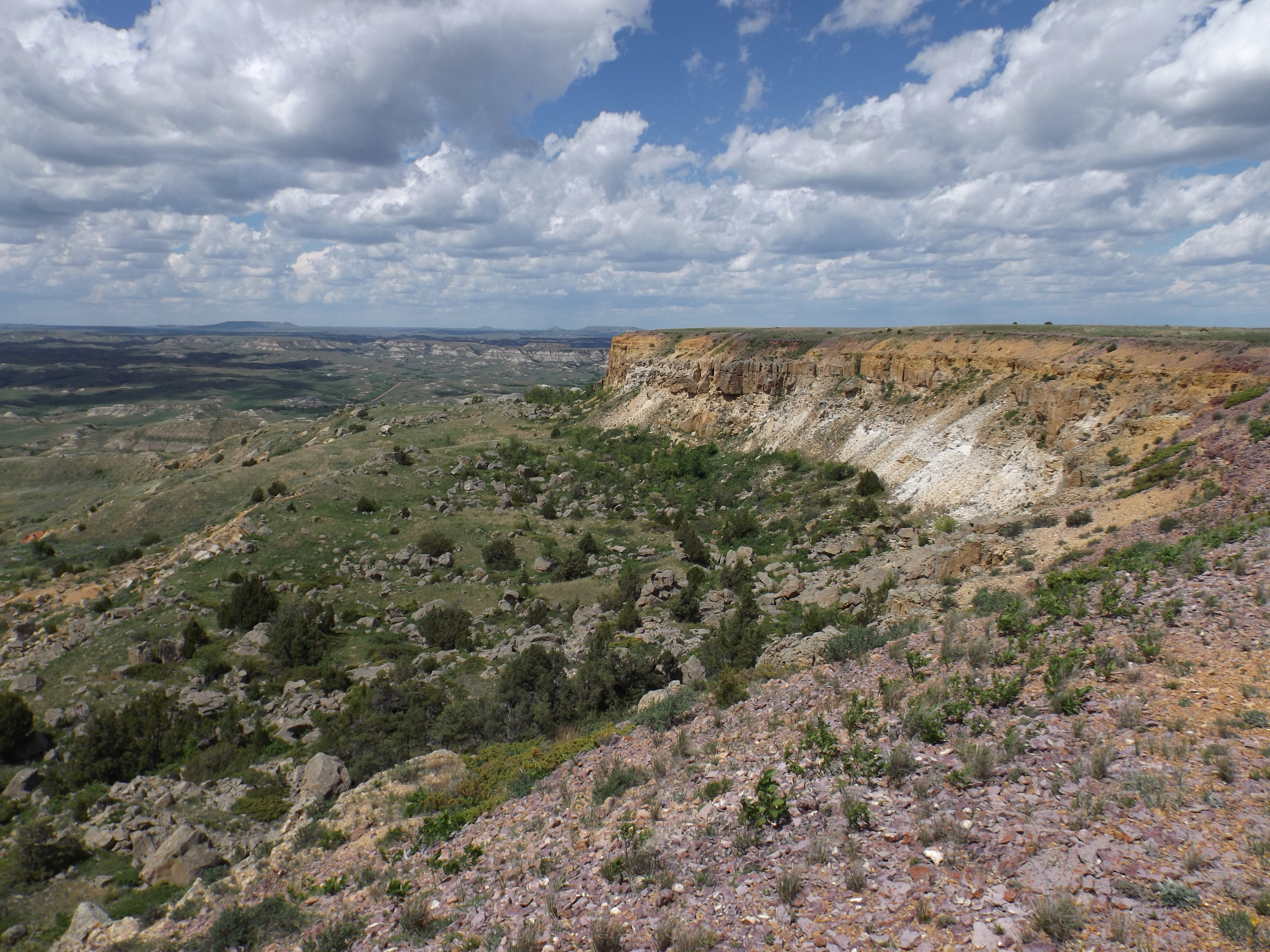
Theodore Roosevelt National Park, the only national park named for a President of the United States, covers about 70,000 acres in three management units in the rugged Bad Lands of the Little Missouri River in western North Dakota. The park is named for the president who lived and ranched here in the 1880’s, before he began his political ascent which took him to the White House in 1901.
The North and South Units of the park, about 50 miles apart along the Little Missouri, contain the visitor amenities: Bad Lands interpretive centers, scenic drives, hiking trails and campgrounds. They’re easily accessible from Interstate 94 and U.S. Highway 85.
About halfway between them is a third unit, the Elkhorn Ranch, a tiny, remote site tucked into the Little Missouri River valley, far from paved roads and power lines.
The Elkhorn was Roosevelt’s home from 1883 to 1887, and it is here, historians say, that he developed the conservation ethic that led him to become our greatest conservation president. Here he grazed cattle, broke broncos, recovered from the death of his wife and mother on the same day, and wrote articles for eastern magazines like Century and Forest and Stream, many of which found their way into two of his best-known books, Ranch Life and the Hunting Trail, and Hunting Trips of a Ranchman.
There’s no little irony in the fact that this place, set aside because of Roosevelt’s great contributions to preservation of public lands, is now perhaps the most threatened by development of all of our NPS areas. So threatened that the National Trust for Historic Preservation named the Elkhorn Ranch one of America’s 11 Most Endangered Historic Places in 2012.
The Elkhorn Ranch is about 35 miles north of present-day Medora, North Dakota, accessible today only by gravel roads. It was here Roosevelt came to be alone, to hunt, to think and to write, and to glory in the quiet and the isolation.
The National Park Service has preserved the site, although the buildings are long gone. A short hike from the visitors’ parking lot, along a grass path, will take you to the very spot TR sat on his porch, marked today only by the sandstone foundation of his cabin. Visitors sit under giant cottonwood trees, between the cabin site and the Little Missouri River, that were saplings in TR’s day, and listen for just the slightest breeze to bring the same rustling sound in the cottonwood leaves that TR heard as he sat in his favorite rocking chair on that porch in the fading evening light. Because of its remoteness, the wind in the cottonwoods and the singing of the birds are about the only sounds at the Elkhorn.
But all that could change rapidly, as soon as this year. North Dakota’s Bakken oil boom, an almost unbelievable explosion of industrial activity driven by the newest oilfield technology, fracking, is moving dangerously close to the Elkhorn, threatening to permanently change this small 218-acre island surrounded by a million acres of Little Missouri National Grassland (LMNG) owned and managed by the U.S. Forest Service. Theodore Roosevelt created the Forest Service, but it was his cousin, President Franklin Delano Roosevelt, who managed the government’s purchase of much of the Bad Lands to save Dust Bowl ranchers, leasing it back to them for pennies on the dollar to keep them on the land. Today, many third and fourth generation ranchers graze cattle on those lands, still paying rent to the Forest Service.
But the grasslands are underlain with oil and natural gas worth millions, perhaps billions, to the federal government, from land which has only generated meager grazing fees from those cattle ranchers for the past 75 years.
The Forest Service now manages nearly 200 million acres of our country’s most fragile lands, but it is mandated by its “multiple use” designation to provide access to oil companies who make lease payments on what is under the ground, and generate royalties from these public lands. The Forest Service’s small staff here, overwhelmed by the current pace of development after 35 years of low-level mineral activity, now dramatically ramped up, creating current threats, can only react to requests to site oil wells and try to enforce reasonably strict reclamation laws. The new gold rush is on.
The First Threat: A Little Missouri River Crossing
Jim Arthaud of Medora, North Dakota, is the owner of MBI Energy Services, one of the state’s largest oil trucking companies. Arthaud has managed to get himself elected chairman of the Billing County Commission, the three-man elected body which oversees the county in which the Elkhorn is located. Arthaud sees the ranch location as the best place to put in a new east-west road, and a bridge across the Little Missouri River, and he’s using his influence as County Commission chairman to do that. The road and bridge would create a shortcut through the Bad Lands, connecting two paved north-south highways used heavily by the oil industry, and bringing as many as a thousand oil trucks a day—many of them MBI’s—within eyesight and earshot of Roosevelt’s ranch. The resultant cloud of dust and cacophony of diesel engines and jake brakes would forever change the quiet, serene river valley. Although many in the oil industry are sensitive to the history of this place, there’s a lot of quiet cheering going on as Arthaud presses his case to the North Dakota Department of Transportation and the Federal Highway Administration, seeking both their approval and their dollars to build the road and the bridge.
Arthaud argues that because river crossings are so far apart—70 miles by road—a crossing here would make it much more convenient for the oil industry to conduct its business. Although the idea of a bridge somewhere between the two existing bridges near the North and South Units has been around since the 1980s, there’s not been much pressure, or interest, from the locals, because few ranchers live along that stretch of the river, and when those few need to cross the river to check on their cattle or visit a neighbor, they can generally do so in their pickups at low water areas of the river, or on the ice in the winter. Fracking has changed all that.
Opponents of the bridge have outnumbered supporters by a three-to-one margin at public hearings required by the National Environmental Policy Act (NEPA). Because of the historic sensitivity of this place, alternative crossing locations a few miles away have been identified, but all would bring the same result to the Little Missouri River valley. Ranchers worry most about the traffic and the fine layer of dust that is already beginning to coat the grasses they need for their cattle. Today there may be a dozen trucks through the area each day, but Arthaud’s own estimate is 1,000 a day if the project is completed. Conservationists and hunters worry about wildlife. Mule deer hunting in the western third of the state has been sharply curtailed because of low populations, and wildlife officials are worried about the impact on sharptailed grouse, elk and bighorn sheep.
Mark Schrader, the Federal Highway Administration official here charged with overseeing the NEPA process, says it is taking longer than usual, but he expects a decision later this year or early next year, and if the project is approved, construction could start in 2014.
The Second Threat: The Gravel Mine
In 2007, conservation groups from around the country, led by the Boone and Crockett Club, which Roosevelt helped found more than 125 years ago, raised several million dollars and were able to purchase a ranch across the river from the Elkhorn to protect it from development. They donated it to the Forest Service, to be managed as a special unit of the LMNG, called the Elkhorn Ranchlands, with its own management plan. Two additional ranches along the river, which, when combined with the Ranchlands make up the entire viewshed from the NPS Elkhorn site, were purchased by a conservation buyer. Those three ranches, originally part of the Elkhorn Ranch where Roosevelt grazed his cattle in the 1880’s, are now being leased to local ranchers for grazing their cattle. But what the conservation groups did not get with their purchase was the rights to the minerals under those lands. Oil development continues there, although Theodore Roosevelt National Park Superintendent Valerie Naylor has been reasonably successful in persuading the oil companies to keep the drilling rigs back far enough from the river to protect the skyline view from the Elkhorn Ranch site.
But Roger Lothspeich, an enterprising businessman from eastern Montana with roots in the Bad Lands, managed to get hold of the rights to what are called “surface minerals”—namely gravel, an increasingly valuable commodity in an area where hundreds of miles of unpaved roads are being built annually to access the thousands of oil well sites, which also need the gravel for their well pads. Federal law gives mineral owners the right to go get their minerals, even if the surface owner objects. And last year, Lothspeich announced, after he had purchased the gravel rights from a previous owner and transferred them to his girlfriend, Peggy Braunberger, “for income tax purposes,” that unless the Forest Service gave Ms. Braunberger a couple million dollars to go away, he was going to dig a great big gravel pit directly across from the Elkhorn and send his trucks in to haul the gravel away. The proposed gravel mine site is indeed visible from the TR cabin site, causing serious concern to the NPS. Park Superintendent Naylor has been vocal in her opposition to the gravel mine. “I’m very concerned about any activity that would bring dust, noise and truck traffic in the viewshed of the Elkhorn Ranch,” she told a reporter last summer.
Public reaction to Lothspeich’s ploy was that it amounted to little more than extortion. Forest Service District Ranger Ron Jablonski refused Lothspeich’s offer, but late last year, after months of wrangling across the table, Jablonski and Lothspeich signed an agreement in principle to negotiate a swap of Lothspeich’s mineral rights for land and/or minerals elsewhere in the National Grassland. Those negotiations are ongoing, and Forest Service spokesperson Babette Anderson, in the Forest Service’s Bismarck, ND, office, said in April that meetings between the two parties are scheduled, but “This could take a long time—years—to settle.” And if no agreement is reached, Lothspeich and Braunberger could go after their gravel.
Meanwhile, Tweed Roosevelt, great-grandson of Theodore Roosevelt and currently president of the Theodore Roosevelt Association, a Congressionally-chartered organization dedicated to preserving the legacy of the 26th President, has asked President Barack Obama to designate the three ranches across the river from the Elkhorn as a National Monument, to prevent further disturbance of the area.
Tweed Roosevelt met with the President to discuss the idea, and said in a followup letter “It would be fitting that Theodore Roosevelt’s Ranch, the Elkhorn, be designated a National Monument under the Antiquities Act of 1906. It was President Theodore Roosevelt who called for passage of the Antiquities Act, and who signed it into law, and it was President Theodore Roosevelt who designated the first National Monuments in our country, among them Devils Tower and Grand Canyon National Monuments. There could be no greater tribute than to include his historic ranch on that list of America’s most important places.”
There’s been no action from the White House on the request so far.
The Third Threat: An Oil Well Next Door
Park Superintendent Naylor spends so much time tracking oil industry activities on her park’s boundaries, she said recently, that it can be close to a full-time job, diverting her attention from other park issues. Already, much of the land around the park’s North and South Units is dotted with oil wells, many of them visible from the park. She said on a recent trip to Buck Hill, the highest point in the South Unit, she could see more than two dozen well sites around the edges of the park where natural gas was being flared.
Naylor discovered a new threat to the Elkhorn this past winter. One of her employees, on a routine visit to the ranch, reported that an oil company had staked out a drilling pad at the gate of the Elkhorn Ranch site, and literally right up against the bank of the Little Missouri, on Forest Service land.
Concerned, Naylor first contacted the Forest Service’s local office to find out why the stakes were there. She learned that indeed, an oil company was looking at the site as a possible location for a multi-well drilling pad. Checking the hearing docket for the North Dakota Oil and Gas Division, which oversees all oil drilling permits in the state, including those on federal land, she discovered that the state was just days away from hearing a formal request from XTO Energy, a subsidiary of Exxon Mobil, to drill four oil wells on the two sections of land adjacent to the Elkhorn.
A flurry of North Dakota news media reports in the days leading up to the public hearing on the request led to some scrambling by all parties, including the Forest Service, the state’s regulatory officials, and the oil company. Although XTO said it had not formally decided to put the well pad at the gate of the Elkhorn—even though the only well site stakes in the entire two sections of land XTO had under lease were just 100 feet from the parking lot—it was going to temporarily withdraw its application for a hearing.
The Forest Service, which was aware of the potential well site but had not notified the Park Service, declared that this was all preliminary work, and that they would work with XTO on a new well site. Spokesperson Anderson said they had not approved the site. “There was no approval at this time since there is no plan, just an idea,” she said. “We looked at both the west and east ends of the lease hold (the Elkhorn is at the east end of the XTO lease) to determine feasible locations with least amount of resource damages and disturbance. The west half of the spacing unit will have extensive disturbances. The lease does not have a No Surface Occupancy (NSO) stipulation next to the park and the site can be located next to the park if the company can meet the Controlled Surface Use (CSU) visual stipulations.” She said that, as of mid-April, “there is no formal proposal or paperwork.”
Superintendent Naylor said she was grateful for XTO’s withdrawal, calling the proposal “the worst threat to the park in its history.” The stakes have been pulled, at least temporarily. When or whether there will be a new proposal is up in the air. XTO has paid a substantial amount to lease the minerals under the land. But all of the land except for the flat river bottom area next to the Elkhorn is rugged, roadless Bad Lands, and the Forest Service has been reluctant to approve well sites on land like that, almost always directing oil companies to areas which will cause the least surface disturbance—which indeed might have been the case here.
In The Government’s Hands
The government agencies involved in all of these potential threats to the Elkhorn—the U.S. Forest Service, the Bureau of Land Management, the National Park Service, the Federal Highway Administration, the U.S. Army Corps of Engineers (which must approve bridge projects over the Little Missouri), the North Dakota Department of Transportation and the North Dakota Industrial Commission, through its Oil and Gas Division—face critical decisions in the coming months.
A hundred and twenty five years ago, our future Rough Rider President mounted his big horse, Manitou, and rode away from here to his date with destiny. He said this was the place where he had found his “perfect freedom.” He left it in our care. By the end of this year, we should have some sense of what the future holds for this spot some call the “Cradle of Conservation.”

http://www.latimes.com/news/opinion/commentary/la-oe-zierman-california-fracking-moratorium-20130621,0,1007838.story
Hope all is well and your are happy…:)
Todd
LikeLike