
I’m beginning to think that Attorney General Wayne Stenehjem might just be ready to really start looking at oil and gas drilling permit applications instead of just giving them blanket approval at monthly meetings of the North Dakota Industrial Commission. That would be the best news to come out of the Oil Patch since fracking was invented.
Stenehjem and some in the conservation community coined the phrase “special places” last May after a couple of controversial permit applications made a lot of news and noise. The first was approval of an application to drill 8 wells near the Killdeer Mountains, in an area that residents and historians felt was “culturally significant.” The other was an application, later withdrawn after media exposure, to drill a well next to the Elkhorn Ranch. Stenehjem said it might be a good idea to make a list of some of the areas that needed to get special consideration when permits are issued. Jack Dalrymple agreed that it might be a good idea to come up with that list, and even go on a little tour to see some of them. Agriculture Commissioner Doug Goehring nodded.
That was six months ago. Since then, a couple thousand permits have been issued with still no formal procedure in place to see if they might be for places that really shouldn’t have an oil well. But there’s been activity on “making a list” on a couple of fronts. Jack Dalrymple went to Little Missouri State Park, where the Commission had already issued a number of drilling permits, and held a press conference to say that he was concerned about issuing drilling permits in places like Little Missouri State Park. Uh huh. And Stenehjem convened a panel of people whose opinions he respected and asked them for advice, but once the news media found out about it, he unconvened the panel.
But as the media (and bloggers) stayed with the story, Stenehjem’s been using some interesting language lately in news stories, where phrases like “extraordinary places that also will include the Little Missouri River and Bullion Butte,” “requirements spelled out in administrative rules,” “requiring pipe placement to avoid flaring natural gas,” and “formal procedure.”
And the latest story in the newspapers says he is going to make some kind of proposal at a December 19 Industrial Commission meeting. All of those reports give those of us concerned about rampant, unrestrained drilling cause for some hope. I’ve been about as critical of the Industrial Commission and its members as anyone, but I’ve never felt it was good to just be critical, without offering some alternative. So last week I sent to Stenehjem my ideas for how the Industrial Commission could begin to examine each drilling permit application and make a decision based on information provided to them by their own state government agencies.
I’m not the only one to do this. Others have also proposed ideas for actual administrative rules, perhaps the ones Stenehjem is referring to, which would require that staff with expertise on the scenic, agricultural, historical, archeological, paleontological, recreational and environmental values of land proposed for oil and gas drilling sign off on permits before they are approved. That would be the best of all possible worlds.
So I’m just going to share with you the proposal I sent to the Attorney General. This is only one idea. I think it would be good if he heard from a lot of people between now and December 19, so please send him yours as well. There’s a nice lady in his office named Liz Brocker who takes e-mails at lbrocker@nd.gov and passes them on to Wayne. I think he reads them. So please let him know what you think as well. There are a whole lot of “special places” in western North Dakota that will thank you. Here’s what I sent to Stenehjem.
SPECIAL PLACES IN WESTERN NORTH DAKOTA
The reality of the Bakken Boom is this: We now have somewhere around nine thousand oil wells in North Dakota, a number which is growing rapidly, on our way to 40 or 50 thousand. The best sites have been cherry picked for ease of access to oil and avoidance of public criticism. There is going to be more and more pressure on permitting agencies to allow development in more sensitive areas as the boom progresses.
The North Dakota Industrial Commission, which grants drilling permits, has indicated a willingness to consider developing some kind of criteria which will require oil companies to consider scenic, agricultural, historical, archeological, paleontological, recreational and environmental values when locating drilling sites. For the purpose of discussion, I have divided sites with these values into three categories.
The first category is for federally owned lands, such as National Parks and National Grasslands roadless areas, which already have restrictions on surface occupancy, but on which the state could add other protections, such as viewshed or noise buffer zones, in the location of drilling sites. In the case of a National Park, for example, a buffer zone could be created that would protect the viewshed from the park. A well might be located as close as a quarter mile from the Park boundary but out of sight of visitors to the park. Or, the Commission might require a well site to be moved two miles from the Park if there is no other way to access a lease without visual interruption to Park visitors. Likewise, if a permit application placed a well too close to a National Wildlife Refuge offering critical wildlife habitat (protected piping plovers, for example), the Commission might create a two-mile buffer zone around that refuge, requiring oil companies to access their lease horizontally—these days not a burdensome requirement.
The second category is lands owned or managed by the State of North Dakota. Generally, except for state school lands given to us at statehood, these are lands which have been acquired because they have some special value—parks, forests, wildlife areas and historic sites. On these lands, state agencies could make recommendations to the Commission about surface occupancy to protect those special values for which they were acquired. That’s already being done on state school lands. So the same process could be applied to other drilling permit applications, using the stipulation criteria already being used on school lands.
The third category is for areas such as buttes, trails and river valleys with scenic or other non-commercial values. These lands generally include a mix of public and privately owned land, so any restrictions placed on them would generally be well-site location recommendations to drillers to protect the scenic value of the areas. An example would be placing a well site out of sight of the front porch of a hunting lodge in the Bad Lands or away from a well-used hiking trail. Oil companies who are good partners and good corporate citizens should be receptive to recommendations from experts on well site locations which are not onerous.
Of course, all of these tasks are going to require sufficient staff at state agencies to review drilling permit applications to look for areas that need special consideration or permit stipulations. It’s a logical assumption that a request from the Industrial Commission to the Emergency Commission for additional FTE’s and funds to hire them will be met with favor. Because state agencies generally have access to GIS map layers, this task is not overly burdensome. It will just require time from agency staffs, and the knowledge, which will increase over time, to make recommendations on oil well placement. Nothing in this proposal will diminish the number of permits issued, nor will it, once implemented, slow the process of issuing permits. It is going to cost the state some money, but in the end it is going to make for better partnership between state regulators and the oil industry. In time, in fact, the industry will come to recognize areas the state is interested in, and incorporate that interest into their permit applications, speeding up the process of permit approval.
The lists below are not intended to create a priority ranking. As one state agency head said recently, “They are all important. They just need different kinds of consideration.” These categories are intended to show that there are numerous areas of special interest—Special Places—which require different kinds of attention in the permitting and drilling process.
CATEGORY 1
Areas managed by federal agencies, that already have some surface occupancy restrictions or stipulations, around which we should create either a buffer zone or require viewshed and noise protection stipulations.
- Theodore Roosevelt National Park, all three units
- Lake Sakakawea, the Missouri River Valley above the lake, and the Yellowstone River Valley
- All non-motorized areas of the Little Missouri National Grasslands, including interior and adjacent state lands
- National Wildlife Refuges, Federal Waterfowl Production Areas, and other areas identified by the U.S. Fish and Wildlife Service as critical habitat areas
- National Historic Sites, Districts and Landmarks
CATEGORY 2
Areas managed by the State of North Dakota in which appropriate state agencies should make recommendations to the Industrial Commission on buffer zones, surface occupancy, well site locations and/or other appropriate stipulations (a model of which is already in use for state school lands), to offer some level of protection to areas in which the state has a significant investment.
- North Dakota State Parks, Forests, Recreation Areas, Preserves, Natural Areas and other lands managed by the North Dakota Parks and Recreation Department or State Forestry Department
- North Dakota State Historic Sites and other historic areas managed, or identified as having historical significance, by the State Historical Society of North Dakota
- North Dakota Wildlife Management Areas and other areas identified as critical habitat by the North Dakota Game and Fish Department
- North Dakota State School Lands (already included in this category and already subject to stipulations)
CATEGORY 3
Areas of particular scenic, agricultural, historical, archeological, paleontological, recreational or environmental significance, not necessarily owned or managed by a government agency, around which we should create viewshed protection, noise buffers and/or attach other surface occupancy stipulations to drilling permits to retain the non-commercial value of these areas. A partial list, which may be enhanced by agencies, organizations or people with expertise in these areas, is included here.
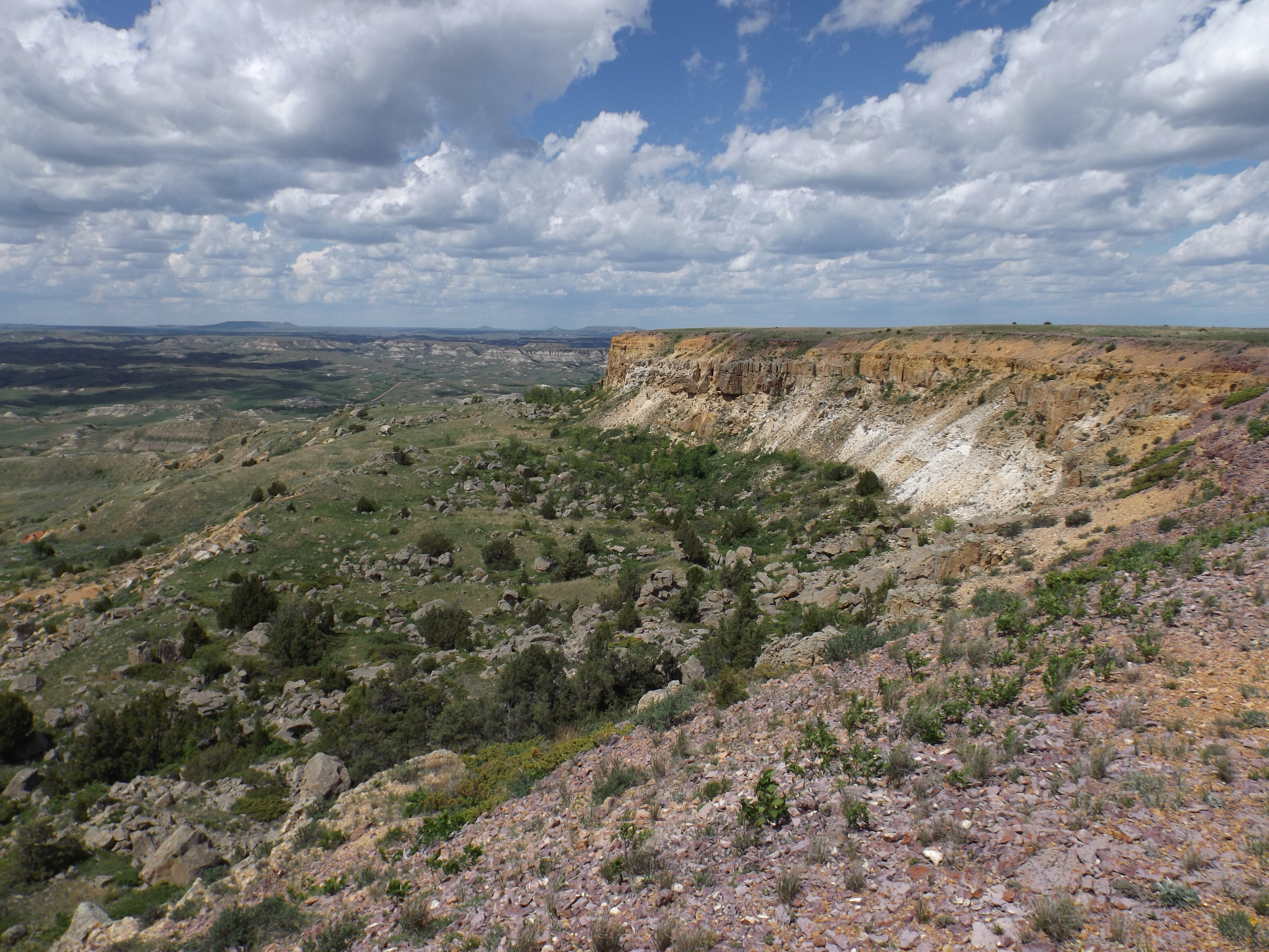
- The Little Missouri State Scenic River Valley
- The Killdeer Mountains
- The west slope of the Turtle Mountains
- The Maah Daah Hey Trail
- Paleontological sites in Bowman and Slope Counties
- Knife River Flint Quarries
- Areas identified by the North Dakota Indian Affairs Commissioner or Tribal officials as having historical, religious or other special significance to Native American Tribes
- Bad Lands scenic areas such as White Butte, Chalky Buttes, Black Butte, Square Butte, Sentinel Butte, Camel’s Hump Butte, Pretty Butte, the Teepee Buttes, the Burning Coal Vein area, the Ponderosa Pine, Limber Pine and Columnar Juniper areas, and Tracy Mountain
In summary, this proposal generally proposes that each drilling permit application from this point forward be looked at by state agency professionals to make sure well sites and other surface disturbances related to oil and gas production are properly located. Such scrutiny will allow our state agencies to also consider the cumulative impact of the oil and gas industry on our natural and cultural resources and recommend to the Industrial Commission additional management practices to deal with that as well.

I wrote to all the members of the NDIC – the governor, the ag commissioner, and the attorney general. The only response I got was a disinterested, generic email from the attorney general’s office referring me back a website. None of my questions concerning special places were answered.
LikeLike
I am proud that you are trying to make a difference in this fracking frenzy! Probably
I have been overwhelmed by the scope of the problem not just here in ND but across the nation and around the world. Choosing to do something positive here is the right thing to do. I will at least write what I think and send it on to the officials that you mentioned.
LikeLike
Jim-
Thank you for your efforts and ideas. I sent a short list of my favorite ideas to each of the IC members last summer but never got any replies My top three sites- The Medicine Hole in the Killdeers, the Burning Coal Vein area south of Medora and the Elkhorn Ranchlands adjacent to the Elkhorn Ranch Unit of TR National Park are all included in your list so I hope they will be on the governor’s list. The main thing is to get some review of drilling permit applications before they are automatically approved.
LikeLike