
Mitigation. There’s a word that draws mixed reaction.
Most dictionaries generally define mitigation as “the act of making a condition or consequence less severe, the process of becoming milder or gentler.”
It’s a word we didn’t much find in common usage in North Dakota until the 1970s, when the Garrison Diversion project surfaced. That project would have destroyed tens of thousands, perhaps hundreds of thousands, of acres of wildlife habitat, and the state of North Dakota and the federal government agreed to a mitigation plan to replace that habitat. The project was never completed. Even mitigation could not justify a really bad idea.
Today, it’s a pretty familiar word here. Our on-the-ground definition of mitigation is “if you screw something up over here, you better do something nice over there to replace it.” Most recently it has come into play as a requirement of a new North Dakota Industrial Commission policy designed to offer some measure of protection to critical wildlife habitat, or scenic, recreational or historic areas near proposed oil development sites. Note I said “designed.” Not “implemented.”
The policy, affectionately known as “Wayne Stenehjem’s Special Places,” was scheduled to take effect on May 1. Essentially it said that after that date, any state-issued permit to drill an oil and gas well in North Dakota on publicly-owned land that is on, or in, or near, any site designated as one of 18 “areas of interest,” might be subject to special conditions designed to “mitigate potential impact to the sites.”
There is no visible indication that the state’s Oil and Gas Division is paying any attention to it, although as of last week, a North Dakota Industrial Commission spokesperson said “There have been no applications for drilling permits on public lands within an area of interest since the policy was implemented on May 1.” We’ll see if Stenehjem, the state’s Attorney General and a member of that three-person Industrial Commission which regulates oil and gas drilling in the state, decides to follow through on his initiative to try to offer some protection, or “mitigate” the damage, to places like national parks and wildlife refuges. Parks, both state and national, as well as all federal refuges and state wildlife management areas in western North Dakota, are on the “Special Places” list.
Including Little Missouri State Park in the North Dakota Bad Lands, about which I want to share a few thoughts. I’ll be as blunt as possible at the outset, and then try to “mitigate” my remarks: The oil industry is on a path to totally trash one of the most spectacularly scenic areas of North Dakota. All in the name of oil company profits. Specifically, ConocoPhillips and Burlington Resources profits. There. I’ve said it. I am not exaggerating. That is what is about to happen. And then they are going to try to mitigate the damage.
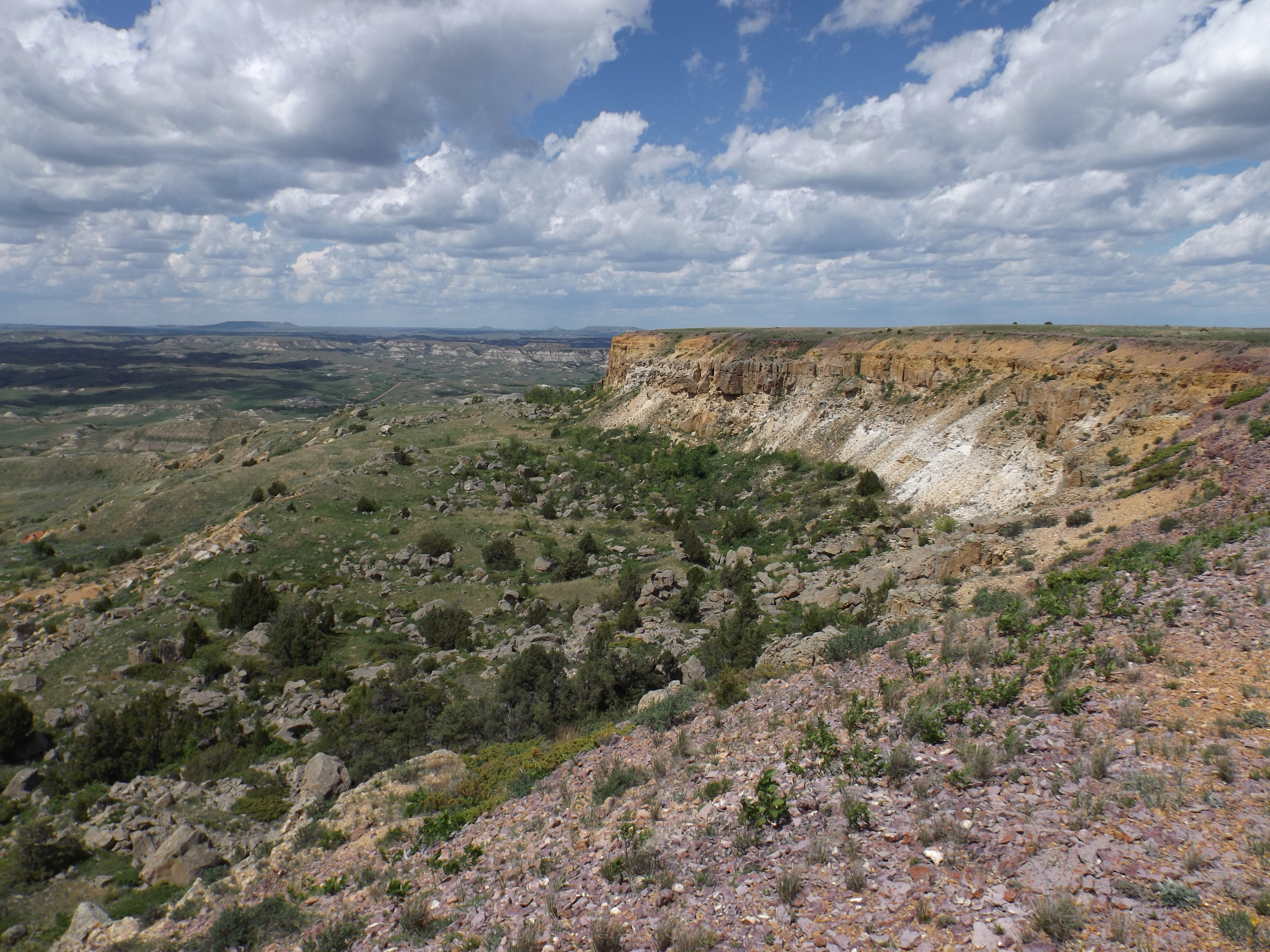
Some background. Forty-some years ago the North Dakota State Parks Department decided the people of North Dakota deserved to have a state park in North Dakota’s Bad Lands. They chose one of the most scenic areas of the Bad Lands, a rugged area where the waters of the Little Missouri River stop flowing and become the Little Missouri Arm of Lake Sakakawea. Here there are hundreds of square miles on either side of the river that are virtually roadless, inaccessible except on foot or horseback. There are likely still places here where no white man has ever stepped. A few ranchers use parts of it to graze cattle and cut hay. Back in 1970, North Dakota converted part of a school section there to a state park, and a couple of those ranch families agreed to lease some of their adjoining rugged ranch land to the State Parks Department so the Parks folks could put some riding and walking trails through the area for the enjoyment of hikers and horse people.

Ever since, thanks to those ranchers, it has been a place of pure escape into North Dakota’s most rugged wilderness for those who choose to take advantage of what the state has provided them in its most spectacular, largely undeveloped park.
Besides the park entrance road off Highway 22, about 20 miles north of Killdeer, there are just a couple of roads into the area on the south side of the river, used by the families who ranch there. Otherwise, except for some two-track trails the ranchers use to get to their cows, the 5,000-acre park is pretty much God’s country. The north side of the river is the Fort Berthold Indian Reservation, and there are virtually no roads to the river for 20 or 30 miles. On the south side, only because of park access, you can hike or ride through the breaks down to the river. But that’s the only river access. No roads.
Until now. Until the oil boom. Soon, this formerly forever-undeveloped area, sculpted by God and wind and water over the ages, unmarred by man, will become North Dakota’s newest oil field. Thank you, ConocoPhillips, Burlington Resources and the North Dakota Industrial Commission. Burlington Resources, the latest incarnation of the minerals division of the once powerful Northern Pacific Railroad, owns nearly half the minerals in a giant oil field created by the Industrial Commission a couple years ago. Enough to dictate how the oil field is developed. The NP acquired the mineral ownership from the federal government when it planned a railroad through the area a hundred and fifty or so years ago, and through independent purchases in later years. It has partnered with ConocoPhillips to develop them (there’s a connection: Warren Buffet’s Berkshire Hathaway company owns the Burlington Northern Santa Fe Railroad and is a major shareholder in ConocoPhillips). They got the go-ahead from the Industrial Commission in a somewhat controversial unitization plan back in 2011. Initially the Commission required Conoco to drill their 80 planned wells in four years and then get the hell out of there and let the oil flow. But now it looks like there could be many more than 80. Plus a couple of huge salt water disposal sites (one is built, one is pending nearly-certain approval of a building permit by the—you guessed it—the North Dakota Industrial Commission) at the entrance to the park, a new landmark for travelers looking to find Little Missouri State Park: “Turn east off Highway 22 at the new Dunn County Industrial Park.”
There’s a pretty good gravel road leading two miles into the state park, but there’s another road just across the fence paralleling the park entrance road. That dirt road leads past the park’s campground, past a private campground and down into a drainage where a brand-spankin’ new scoria-covered oil pad sits waiting for the drilling rig to arrive.

It will come in November and drill up to five wells less than a mile from the campground. Up to 5,000 truckloads of fracking water will pass by the campground next winter if all goes as planned. The good news is, the campground is closed in the winter. ConocoPhillips has agreed to do the drilling over the winter so the park will see less disturbance than if it happened in the summer. Still, there’ll be plenty of traffic in and out just from normal well service once the oil is flowing. It’ll be a much less desirable place to camp.
But I started to write about mitigation, and I want to get back to that. The campground is just one small area of the park. The major activity in the park is use of the trails on the private land leased to the Parks Department down into the breaks. And the trails are going to be heavily impacted. In fact, some of them will be destroyed by the new roads down to numerous well sites scattered throughout the park. Park officials tell me that there is now a map of where all the wells will be. And where the access roads to those wells will be. I don’t want to see it. As someone who has hiked those trails, I am afraid it will break my heart. But rather than abandoning the park’s major use, those backcountry trails, the State Parks Department is going to sit down with the ranchers from whom they lease the land and seek permission to build new trails. Remember, those ranchers still run cows here, and that is their livelihood, so they’re going to be pretty careful about where any new trails go.
Conoco will pick up the bill for any new trail construction. Where roads and well pads are visible from the trails, the parks people will try to move the trails to areas where, hopefully, the development is less intrusive. If it all works out, beginning next summer, park users will find new views and experiences awaiting them. The oil development won’t be invisible in the park, one parks department official told me, “but we’re going to do the best we can.”
That’s mitigation, and Conoco is being pretty magnanimous about it, including opening their checkbook. But the mitigation will only satisfy the humans. You can’t mitigate the damage to the land that is going to be disturbed for the first time ever by roads designed to carry thousands of trucks, or the destruction of wildlife habitat and temporary wetlands and game trails and raptor nests. The damage to them is going to be permanent, not just from the new roads and the well pads, but also from the new trails being built to accommodate humans. You can’t mitigate the noise and dust those thousands of trucks will bring, disrupting the critters’ lives.
Because mitigation doesn’t make things whole. It just makes the best of a bad situation. Little Missouri State Park is one of those “special places” that isn’t going to be so special any more.
You can’t mitigate greed.

Well done Jim. What I read about the disaster raining down on the beauty of western ND breaks my heart. I can’t imagine living there and seeing the clouds gather!
LikeLike
Well written. Too bad that it will be a least a generation until Residents of ND wake up to the plundering of our land, and vote the Republican super majority out of power.
LikeLike
I was out to LMSP last weekend and saw the road to the new well pad which goes right by the campgrounds. Unfortunately I did not have time for any hiking. I think the people of North Dakota do not know what is at this park. It would be great if some very good photographers could spend some time there and document the place before and after oil development. Carefully document every picture with dates, time and GPS coordinates and then publish them as extensively as possible. The State Parks and Recreation Department has an excellent facebook page for advertising its parks. It provides lots of pictures and schedules of events at twelve of the thirteen state parks. Guess which one they never mention. Out of sight out of mind. If the citizens don’t know about the park they won’t complain when it is trashed.
LikeLike
One of my favorite spots in all of North Dakota. I am afraid to go there now. It could trigger some serious weeping.
LikeLike
Laurel: I have not been out there since 2007 for the exact same reason. I don’t want to go because I’m afraid my memories of the ND prairie will be forever changed for the worse. Maybe if enough of us go out and visit our old “memories” we can affect some kind change. However, I fear that greed is to strong to preserve a place for future generations. Will this be our generation’s legacy?
LikeLike
By law, any policy that has a significant effect upon the public has to go through the rulemaking process in order to be enforceable. All there is right now is a feel good policy that if push comes to shove, the Industrial Commission cannot enforce if it has a significant effect. Therefore, I would conclude it is functioning as it was intended, no significant effect.
To read the law, go to the Administrative Agencies Practices Act North Dakota Century Code 28-32.
LikeLike
Great story. What else is coming to the LMSP area is a fresh water loading facility next to the salt water disposal well complex, an oil field waste dump by the salt water complex, and 19 oil wells lining the road from the salt water complex to the LMSP. In May the NDIC took the power to regulate waste dumps away from Dunn Co. and is allowing waste dumps to be built next to salt water disposal wells. On Dec 20th of 2011 when the NDIC Unitized the Corral Creek Field they used the excuse that they had to do it to protect the park. You are now seeing the devastation of unitization. Without unitization they would have only been able to drill 54 wells. Now they have already drilled over 90 and are on their way to over 300 wells surrounding the park. Unitization was just an excuse to take away the right of the mineral owners to lease their minerals and receive all of their royalties. You are right when you say greed is causing the destruction of a very pretty area. I grew up next to the park and roamed that area on foot and horseback before it became a park. It is lost all because of greed and corruption.
LikeLike