
I love the Little Missouri River. It is one of the longest free-flowing rivers in America.
In reality, I believe it IS the longest, because the Yellowstone, which claims the honor, is full of low-head dams that create little pools and eddies all along its length, even though they don’t create giant reservoirs like the Big Missouri’s dams do. The Little Missouri has none of those. It just runs and runs and runs, unimpeded, and it is a joy to behold, on every one of its 560 miles. It is truly “free-flowing.”
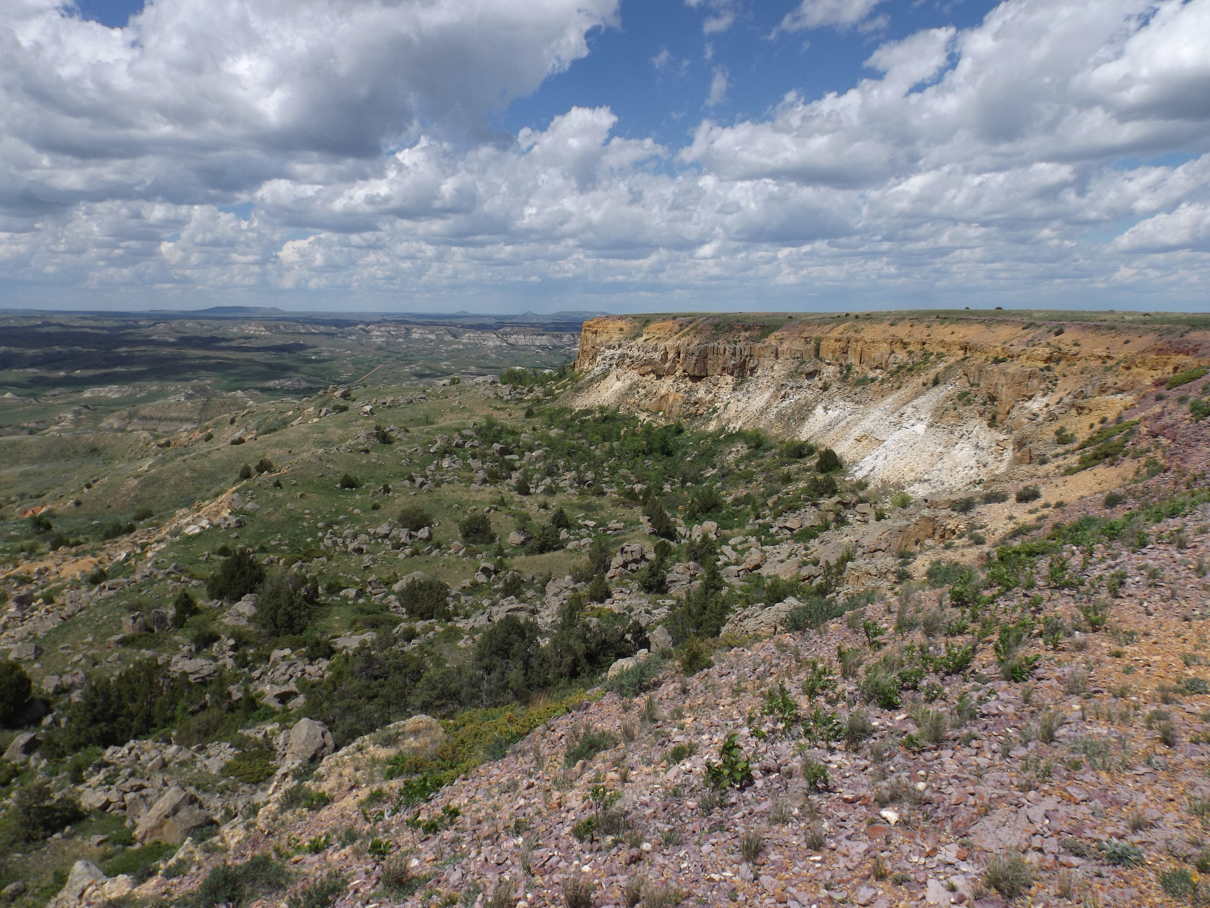
I love the Little Missouri River because it carved the North Dakota Bad Lands, a place where I spend much of my time, a place written about so much, by so many people, I won’t even start here.

I love the Little Missouri because it is accessible. It has hundreds of miles of public lands on one side or the other, land we own and which we can use to get to this marvelous river. And when we get there, we can almost always walk right across it. For probably most of ten months of the year it is either low enough to walk across without getting your underwear wet, or frozen solid. It’s a river that invites participation. It says “come on in,” or “come on over.” There’s simply nothing finer than to strip down to that underwear on a hot summer day and sit down in the deepest hole you can find where you are, often only 6 inches, and just let the water meander by, splashing it on your face and body to cool off.
I took my wife Lillian there on our first date. Actually, it may have been her idea, but I drove, so I guess “took her there” is accurate. We drove through Medora, north through Theodore Roosevelt National Park, and up East River Road to the Buckhorn Ranch. We parked my jeep on the bank, and walked across the river to the Elkhorn Ranch, where we sat on a fallen cottonwood trunk beside the foundation stones of Theodore Roosevelt’s cabin (a tree which surely was standing, although just a youngster, when TR lived there) and had a picnic. I remember the date: February 2, 2002. It was about 20 degrees, there was no wind in the Little Missouri River Valley, and there was about six inches of snow on the ground, perfect for a winter’s day hike. Across a frozen river.
Lillian’s a birder, I’m not, and she pointed out a northern shrike, a medium sized grey bird which catches little critters like field mice, and impales them on spikes or barbed wire fences to kill them before eating them. I didn’t know that. I’m not sure I wanted to know that.
Here’s another reason I love the Little Missouri. It rises in Crook County, Wyoming, just below Devils Tower. Lillian’s last name is Crook. The county was named, of course, for General George Crook, the famous Indian fighter. There may be some connection. If not, at least being married to a woman who has the same last name as the county which gives birth to one of the world’s greatest rivers is good enough for me.
Enough romance. Here’s what I want to write about. What got me thinking about the Little Missouri this Spring was the article I wrote a couple months ago about the 4-lane project for Highway 85. That’s the north-south U.S. Highway through the Badlands. I was reading some comments on the project by Jan Swenson, the executive director of the Badlands Conservation Alliance, a Badlands watchdog organization.
Jan suggested that the North Dakota Department of Transportation, in charge of widening the highway and replacing the historic Long-X Bridge over the Little Missouri River, consult the Little Missouri Scenic River Commission, for their feelings about how to approach the issue of a new four-lane highway through the Little Missouri River Valley.
Well, I bet not a lot of folks remembered the Little Missouri Scenic River Commission from the days it was active. I decided to refresh my memory. I went looking in the archives of the State Historical Society of North Dakota, and I found a set of files, about 12 inches thick, the “Minutes and Correspondence of the Little Missouri Scenic River Commission – 1976-1998.”
Here’s what I learned: There’s a state law, dating back to 1975, that says
“The purpose of this chapter shall be to preserve the Little Missouri River as nearly as possible in its present state, which shall mean that the river will be maintained in a free-flowing natural condition, and to establish a Little Missouri River commission.”—North Dakota Century Code 61-29-02
The 1975 North Dakota Legislative Session was not like any session of the North Dakota Legislature in recent memory. In 1975, Republicans and Democrats disagreed from time to time on matters of major policy, but they got along after the votes were counted, and they recognized that some things transcend party politics. There’s not much of that going on here, or in most states, or certainly nationally, today.
The 1975 North Dakota Legislature passed a bill that started with the words “This chapter may be cited as the Little Missouri State Scenic River Act.” And that’s how we came to have the Little Missouri State Scenic River, North Dakota’s only designated State Scenic River.
And in so designating the river that carved our magnificent Bad Lands, they created the Little Missouri Scenic River Commission, and said:
“The commission may advise local or other units of government to afford the protection adequate to maintain the scenic, historic, and recreational qualities of the Little Missouri River and its tributary streams. The commission shall also have the power and duties of promulgating management policies to coordinate all activities within the confines of the Little Missouri River when such action is deemed necessary.”
Continuing, they said: “Channelization, reservoir construction, or diversion other than for agricultural or recreational purposes and the dredging of waters within the confines of the Little Missouri scenic river and all Little Missouri River tributary streams are expressly prohibited.”
“Promulgating management policies.” Hooray for them. Those words exist today in North Dakota state law, Chapter 61-29. Except no one pays attention to them. Those are words which would never become part of state law if such a law was proposed today. It’s probably still on the books because no one remembers it, which gave me pause in writing this article. But I am calling attention to it because there is much that could be done if the Commission saw fit. Unfortunately that’s not on anyone’s agenda these days. And the Little Missouri, America’s longest free-flowing river, is threatened because of it.
The Commission consists of a representative of each of the six counties that are home to the Badlands, plus three state agency heads, from the North Dakota Parks and Recreation Department, the North Dakota Water Commission, and the North Dakota Department of Health. County Commissioners appoint their representatives, and they must be ranchers whose land abuts the Little Missouri River, a fine qualification, I think.
Created in 1975, the Commission held its first meeting on November 10, 1976. Parks Director Gary Leppart explained to those present that the Commission was to “serve as an advisory group to any or all units of government with regard to river management.”
Fences across the river were one topic of discussion at that first meeting, but the most time was spent discussing a proposal by a company called Tenneco to put a dam on Beaver Creek, a major tributary of the Little Missouri, to provide water for some kind of energy project they were contemplating. Because the Commission consisted of mostly ranchers, they were pretty skeptical of that. The plant was never built, but I didn’t dig deep enough into the subsequent meeting minutes to see if they were instrumental in that.
But that set the tone of the Commission’s activities. The state was just entering into its first oil boom, with much of the oil activity taking place right there in the Bad Lands, and the minutes and correspondence for much of the next seven or eight years are consumed with oil activity around the Little Missouri River. Meetings were held once a year, or more often if needed, but because the group came from a large area, stretching from the South Dakota border almost to Canada, plus three from Bismarck, much of the discussion was done by mail (no e-mail in those days, and even conference calls were not that common), and decisions were often made on sticky issues by sending out ballots for members to vote on and return.
Back then, pipelines were the order of the day, to serve the oil companies’ needs to move oil and gas. Pipelines generally ran from west to east. Much of the drilling was west of the Little Missouri. That meant they had to cross the river. And when they did, the Commission weighed in. Generally, they approved them, but often with suggestions for modification, or a change in course, or for additional safeguards. Pipelines were pretty safe in those days, for some reason—spills were uncommon, unlike today.
For example, on August 29, 1980, the Commission received a request from Matador Pipeline Company to run a pipeline under the river in McKenzie County. At the conclusion of the letter, Matador’s project leader, L.C. Mann, wrote “Matador Pipeline, Inc., shares the Little Missouri Scenic River Commission’s concern that the ‘River’ be protected and preserved in its natural state where ever and whenever possible.”
Just 12 days later, on September 10, after consulting members of the Commission, Robert Horne, State Parks Director and Secretary of the Commission, wrote back:
“Permission is granted to cross the river with the understanding that you will do your utmost to protect the aesthetic and scenic qualities of the river and surrounding area.
“I learned from the State Land Department there are a considerable number of trees on either side of the river where you intend to cross. I also learned there is another pipeline crossing within one-half mile of your proposed crossing. If there is any way to cross near the existing crossing which has already impacted the river, this would be preferable. If you must cross where you originally planned, be careful to exert the utmost effort to protect and preserve as many of these scarce river bottom trees as possible.
“Thank you for keeping us aware of this project and for treating the river with respect.”
Can you imagine such an exchange taking place today? Hardly. And in 12 days, not 12 months? Impossible. But it seems to me that is the way government ought to work. Respectfully, on both sides.
On the other hand, the Commission was no “rubber stamp with kind words of protest.”
At about the same the Commission was considering Matador’s pipeline request, a company called Mile High Exploration requested permission to seismograph 50 miles of the riverbed to provide seismic information to oil companies. Here’s Horne’s letter to that company:
“Following your presentation August 27 to the Little Missouri Scenic River Commission, the Commission voted to deny your request… Basically, the Commission felt this information could be gathered by seismographing on either side of the river some distance away, that there would be undue and unnecessary disturbance to the scenic river . . . that it might set a precedent . . . (and) that this would lead to oil exploration in the bed of the river, something they wish to avoid.”
I wish I could say that the Commission was still active and still taking care of the Little Missouri River the way it should be taken care of. Sadly, that is not the case. I’m still looking into that. I’ll report in when I have more information. Thanks to Jan Swenson for calling this to our attention.

Great story about a government agency that I had never heard of. I will be very interested if you follow up on this and let us know what happened to the commission and why the current government can so blithely ignore the law.
LikeLike
Interesting opinion piece. I too was unaware of this commission to protect the Little Missouri and I have lived right along side it for over 60 years.
In my experience,there are more than two months of the year when you can’t walk across the river. Strictly speaking the river is free flowing but when the ice goes out in the spring, it usually jams somewhere around the Lost Bridge because of the impending non-flowing Garrison Dam, which causes flooding along the river bottoms. One other point I need to correct, not all public land is accessible without going through private property and private roads. So far, land owners still have a few rights but they are dwindling, which by the gist of your writings, is your goal.
LikeLike